Wild Trails Wales Guide: Hiking in the Brecon Beacons

Hiking in the Brecon Beacons National Park
The Brecon Beacons National Park is one of the most popular places for hiking in the UK, as it is home to the highest mountains in the south of Britain, although the majority of visitors head straight for the most popular spots of Pen y Fan, the highest peak, and Waterfall Country, where series of waterfalls cascade through steep woodland gorges.
This is far from the whole story however, and even though I’ve spent years walking in the Brecon Beacons I’m yet to visit everywhere I’d like to see and I’m regularly discovering new favourite walks and places to explore. If you’re visiting the Brecon Beacons for the first time, or would like to explore beyond the most popular places, and don’t know where to start, I hope this mini guide will help.
Mountain Ranges
The mountain ranges of the Brecon Beacons National Park are what draw so many people to the area. Formed predominantly from sedimentary rock, some of which are 400 million years old, the land has been tilted and folded over the years, and the most recent large scale landscape change was during the ice age, when glaciers carved out dramatic escarpments and ridges, leaving the smooth glacial valleys and peaks that the Brecon Beacons is so well known for, behind. There are four main mountain areas, the most popular being the Central Beacons. From the Black Mountains in the far East of the park, to Mynydd Du (The Black Mountain) in the far West of the park, the park comprises just over 500 square miles, with more than 20 mountains over 600m.
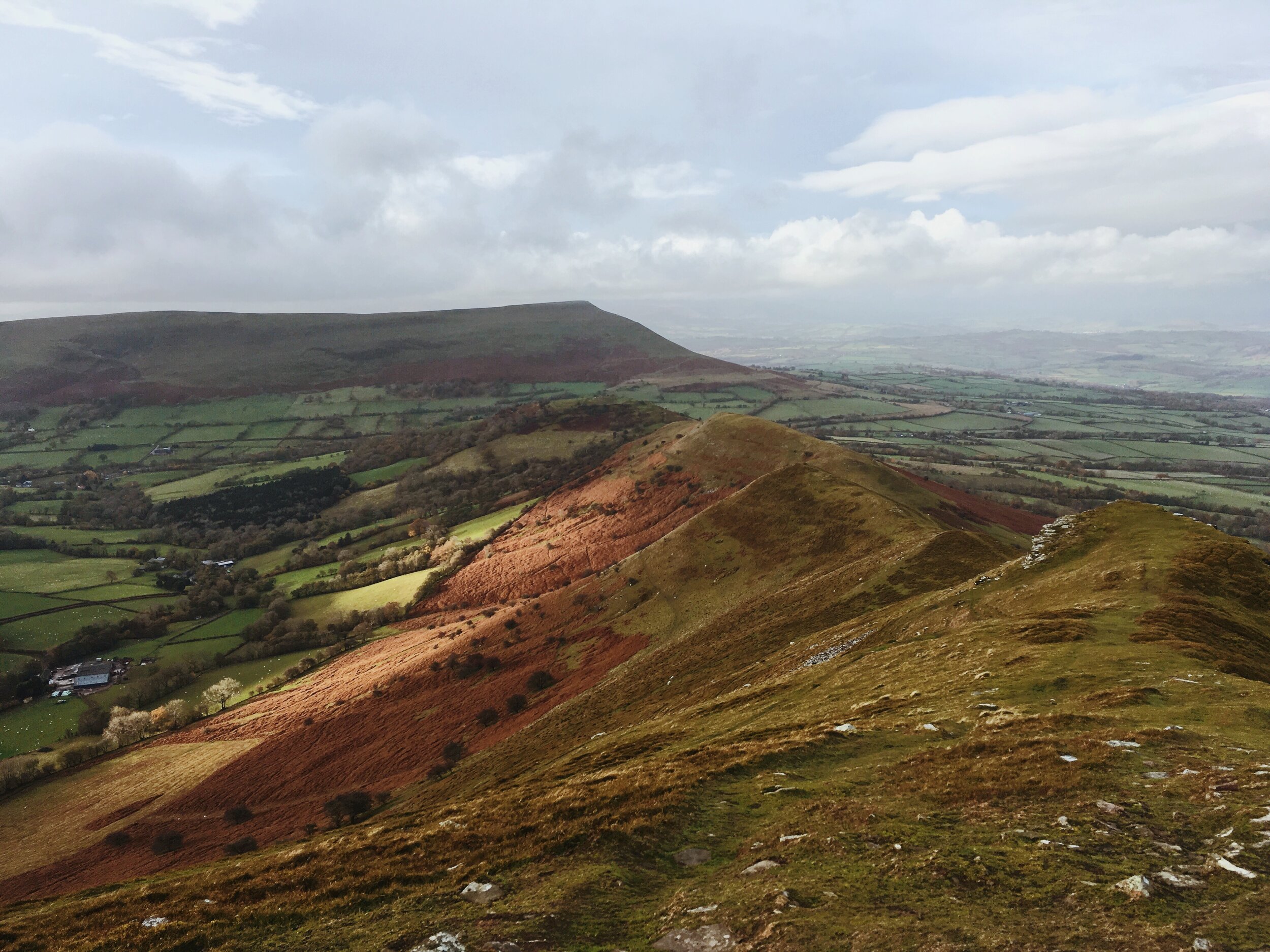
Y Grib in the Black Mountains
Black Mountains
In the far east of the National Park, the Black Mountains are broad moorland peaks with glacial valleys extending in several directions. The highest peak is Waun Fawr, at 811m above sea level. Other popular peaks in the area are Twmpa (also known as Lord Hereford’s Knob), Hay Bluff, Pen Allt Mawr, and the Black Hill. I still have lots of this area to explore, but one of my favourite routes, and generally popular, is the route up Y Grib (known as The Dragon’s Back) which is a lovely grassy ridge walk, then up along boggy moorland to Waun Fawr. Keep an eye out for Grouse, Kestrel, Merlin and Buzzards. If you spot sheep fleece in piles across the moorland, don’t panic, there’s not a terrifying beast on the loose (well not that I’ve seen anyway!) but an innovative project to restore the valuable peat land back to health, as it is such an important carbon store.
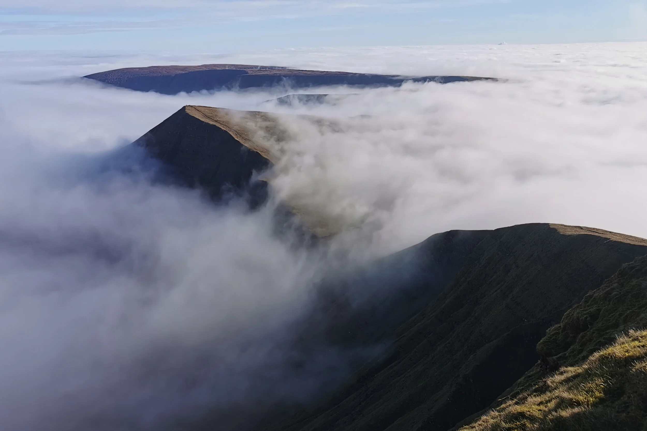
Misty morning in the Central Beacons, looking towards Cribyn from Pen y Fan
Central Beacons
The most popular range in the National Park, and one that many visitors won’t venture beyond, this range does however deserve the attention it gets, with its charachteristic glacial escarpments and airy ridge walks. Pen y Fan, the highest point in the park, is 886m above sea level, though easily reached from the A470 main road, with a well made and easy to follow path starting at 450m above sea level. That’s not to say it is without its challenge, and apart from the obvious danger of the very sheer escarpment, when the clouds come in, as happens so frequently here, it is easy to get turned around at the top and descend in the wrong direction. A classic and challenging walk is the Beacons Horseshoe, taking in the peaks of Pen y Fan, Corn Du and Cribyn. Visit Fan y Big to stand on the infamous ‘diving board’ rock which juts out terrifyingly over the edge of the peak.
The view from Fan Gyhirych down towards Crai Reservoir
Fforest Fawr
One of the quietest of the mountainous areas of the National Park, Fforest Fawr consists of moorland and more gentle escarpments, with the highest points being Fan Fawr and Fan Gyhirych. Fan Fawr is a great alternative to Pen y Fan, as it is equally accessible, sharing the same car parks off the A470, though there is no well made path and it is very boggy in places so you’ll need good navigation skills here in poor weather. Surprisingly, being so close to Pen y Fan, you’ll see very few people up here, and you have the bonus of enjoying great views of Pen y Fan when the weather is kind. Another great walk in this area is around the quiet and craggy glacial valley of Craig Cerrig Gleisiad, with great views, interesting geology and wildlife, and despite being just moments from the A470, you feel as though you’re a million miles away. Even quieter is the walk up Fan Gyhirych, and there is a forestry track for much of the walk, making navigation fairly straight forward.

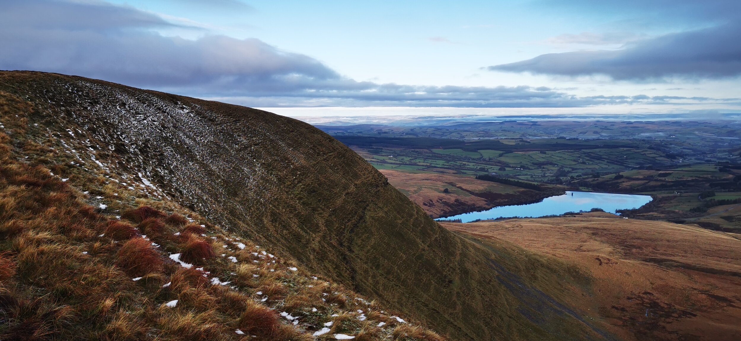
View of Mynydd Du and Llyn y Fan Fach
Mynydd Du (Carmarthenshire Fans)
Many a visitor has come unstuck confusing Mynydd Du (Black Mountain) with the Black Mountains, plural, in the east of the park, so here’s your head’s up! Until recent years this part of the park was very quiet, and a local’s best-kept secret, but Instagram has put paid to that and now you can rarely move for getting smashed in the head by a drone or tripping over ‘wild’ campers in these parts, though I have to admit that the photography that is produced in this area is spectacular and you can see why it has become a photographer’s mecca. Fan Brycheiniog is the highest peak here, and is suitably dramatic, offering one of the best circular mountain days in Wales. Don’t miss Llyn y Fan Fach and Llyn y Fan Fawr, two lakes sitting impossibly pretty at the base of the mountains. There are still many quiet spots to be found in this range. Fan Hir is worth a visit for its lovely ridgeline walk, as well as the mysterious Garreg Las, topped with enormous Cairns, which feels very remote and is perfect for getting away from it all if you’re not concerned about climbing the highest, or most dramatic peaks.
Lowland
Although the Brecon Beacons is a popular hiking destination because of its mountains, there is such a wealth of beautiful places to explore in the lowland areas that it would be a shame to miss out. Below are some of the best lowland walking areas in the Brecon Beacons National Park.

Taf Fechan Forest in Autumn
Woodland
The Brecon Beacons has hundreds of miles of woodland trails to explore. The vast plantation forests of Coed y Rhaiadr near Pontneddfechan; Coed Taf, off the A470; Taf Fechan and Talybont forests in the central part of the National Park; Glasfynydd near Crai in the western part of the park; and Mynydd Du forest in the east all have forestry tracks and trails to explore.
Native deciduous woodlands exist in smaller pockets - including Parkwood in Talgarth, Glyn Tarell near Brecon, Coed Cefn near Crickhowell and Coed Letter near Myddfai.

Llangorse Lake
Lakes, Waterfalls & Gorges
One of the most popular parts of the National Park is so-called ‘Waterfall Country’ near Pontneddfechan. Here there are 10 accessible waterfalls and beautiful woodland walks along the steep gorges. It’s an area not to underestimate as the paths can be very slippery, steep and precipitous - and I reckon almost as many rescues are carried out by Mountain Rescue here as any other part of the park. It’s also an area which is under a lot of pressure due to overtourism, and an unsustainable number of visitors. If you understandably really want to visit this area, my advice would be to avoid peak times, choosing a weekday out of school holidays and in the morning or evening. A good alternative is the Taf Fechan between Pontsticill and Talybont, or the walk to Pwll y Wrach falls near Talgarth.
Llangorse Lake is the largest natural lake in south wales and has a beautiful walk around its circumference, through scientifically important wildlife meadows and with fascinating history. There is plenty of parking and good facilities here too, and it’s a great option for a bad weather or relatively flat walk.
Another good lowland waterside option is the riverside trail from Hay on Wye to Glasbury along the river Wye.
For anyone with limited mobility wanting a beautiful accessible trail, you could follow the very pretty Brecon and Monmouthshire canal towpath - there are access point all along the canal but a great starting point is the canal basin in Brecon or in Talybont. Other good options are at Craig y Nos country park, and the Sgydau Sychryd accessible trail in Waterfall Country.
Trails
There are hundreds if not thousands of miles worth of established trails within the Brecon Beacons National Park, so really you’re spoilt for choice. If you like the idea of following an established route, below are some of the more well-known trails within, or passing through the Brecon Beacons.

Cambrian Way marker in Fforest Fawr
Beacons Way
The main long distance route offering a traverse of the National Park, this infuriatingly 99 mile long trail (why?!!!!) offers the ultimate immersion in the Brecon Beacons. There are parts of the route that I would change, but overall you’ll get to visit most of the prominent peaks and some lovely villages and towns.
Offa’s Dyke
The Offa’s Dyke National Trail passes through the Brecon Beacons National Park at Hay on Wye, over the Black Mountains above Llanthony.
Cambrian Way
The Cambrian Way is a spectacular route which crosses Wales from North to South, and a large portion of it traverses the Brecon Beacons National Park, sharing some parts of the route with the Beacons Way.
Taff Trail
The Taff Trail is a multi-use trail which passes through the National Park from Merthyr in the south to Brecon. As it is part of the cycle network, expect to be sharing this trail with cyclists, though that doesn’t mean that it isn’t rough or hilly in places!
Shorter Trails
For a shorter but nonetheless beautiful and interesting walk, you could follow the Four Falls, Elidir or Gunpowder trails in Waterfall Country. Maps are available online or from the National Park visitor centre.
Underground
You can’t really write a guide to walking in the Brecon Beacons without mentioning the amazing network of caves that can be found in the limestone areas of the park - there are miles and miles of caves to explore, though with the exception of Dan yr Ogof showcaves in Glyntawe, you need a qualified guide in order to gain access and stay safe. Check the National Park website for companies offering guided trips into the caves. If you want to get a glimpse into the underground world without actually going in, you can visit the enormous cave mouth Porth yr Ogof near Ystradfellte.
Places to Stay & Eat
The Brecon Beacons National Park has some lovely small towns and villages that make great bases and offer facilities including food and outdoor shops, cafes, restaurants, accommodation, museums and more.

Hay on Wye is a popular town full of book shops
Brecon
Starting with the namesake town which is the central-north gateway to the park and the obvious choice for visitors who want quick access to the Central Beacons as well as the option to head east or west. Brecon is an ancient town full of history, set on the beautiful river Usk, with plenty of accommodation, shops, cafes and restaurants.
Hay on Wye
In the north east of the park, Hay on Wye is famously known as the ‘town of books’ and was once declared and independent kingdom! The lively town is full of independent shops, many of which sell books and antiques, plus plenty of places to eat and stay, and with great access to the Black Mountains.
Talgarth
A small town, but with good options for staying and eating, this town also offers great access to the south-western Black Mountains.
Crickhowell
A beautiful riverside market town, Crickhowell offers some more luxurious accommodation options, plus a great tourist information centre and its very own walking festival. This town offers good access to the south of the Black Mountains.
Pontneddfechan, Penderyn and Ystradfellte
These are the gateway towns and villages for Waterfall Country and all have parking (though all car parks fill up very early during peak times), public toilets and places to eat.
Trecastle & Crai
More villages than towns, there are nonetheless some good accommodation options here and a few really nice places to eat. Good for access to the Fforest Fawr and Mynydd Du mountains.
Llandovery
Just outside the National Park boundary, this lovely market town offers good access to the west of the park, with plenty of accommodation options, shops and places to eat.
Responsible Travel
The Brecon Beacons is a designated National Park for a reason - it is important due to the nature, scenery, beauty, culture and history of the area, and when we’re visiting the park we have a responsibility to keep it that way for those who come after us.

Dawn in the Brecon Beacons National Park
Spread out
Consider visiting some of the less busy areas in the park to avoid adding to pressure in these areas. and if you can, visit outside of peak times.
Don’t light fires
In spring and summer especially this delicate area is very vulnerable to forest and grass fires which could destroy peatland releasing huge amounts of carbon into the atmosphere, even with the best intentions fires can accidentally get out of hand so better to be safe than sorry.
Take your litter home & go to the toilet responsibly
Public toilets are available in most of the towns mentioned above, plus at the Storey Arms car park and National Park visitor centre in Libanus. If you get caught out in the more remote areas, make sure you go away from trails, buildings or waterways, take any tissue out with you, and dig a deep hole for anything substantial and make sure it is buried afterwards!
Support local businesses
You’ll be hard pressed to find any massive chains or big brands in the national park anyway, but do consider using independent shops, visiting farmers markets, staying in official campsites and eating locally produced food - you’ll get an enriched experience of the national park if you do anyway!