Snowdonia Day Walk : Glyderau from the South

Castell y Gwynt with Glyder Fawr behind
The Glyderau offer an other-worldy landscape of weather shattered rocks, in intruiging formations, revered by those who know and love them. Legend says that never a day shall pass without cloud on this third-highest mountain range in Wales, so bring your best navigation skills for this walk.
Need to Know
Best time to walk: Dry, mild weather is best for this route, as rocks can become slippery in rain or ice.
Map: OS Explorer, OL 17 for this route
Start: Pen y Gwyryd
End: Pen y Gwyryd
Distance / Time: 9.8km / 6.2 miles
Ascent / Descent: 814m
Transport / Parking: Snowdonia Sherpa buses stop at the Pen Y Gwyryd and Pen y Pass. Several pay & display parking laybys near the Pen y Gwyryd.
Food / Drink / Supplies: Pen y Gwyryd hotel for drinks. Nearest shops in Beddgelert, Betws y Coed or Llanberis.
The Route
View route map (you will need an OS Maps online subscription to access it.)

View of Crib Goch from Miners Path up to Glyder Fach
Begin your walk by crossing the stile next to the Pen y Gwyryd, crossing the river on a footbridge, then heading up alongside a stone wall going north-east, until the top of the wall, where you’ll cross it as it heads east at just over 400m above sea level. From here continue up for another 250m of ascent, generally north-east, on a fairly visible path, until you reach a waterfall. Cross the stream just below the waterfall.

Climb steeply with the waterfall to your left, before the ascent becomes more gradual, and finally you emerge onto the plateau near Llyn Caseg Fraith. Head north to the cliffs overlooking Tryfan and the Carneddau for a fantastic view.

Snow capped Carneddau on the other side of the Ogwen Valley.

Tryfan with the Carneddau behind

Looking back towards Llyn Caseg Fraith and Y Foel Goch
Keeping the cliffs on your right, continue uphill on an easy scree track, with a couple of sections of easy and fun scrambling between the jagged shattered rocks to reach Y Gwyliwr (the cantilever stone). Take care not to stray north onto Bristly Ridge. Continue west-south west to Castell y Gwynt, which you may want to bypass slightly to the south to continue on.
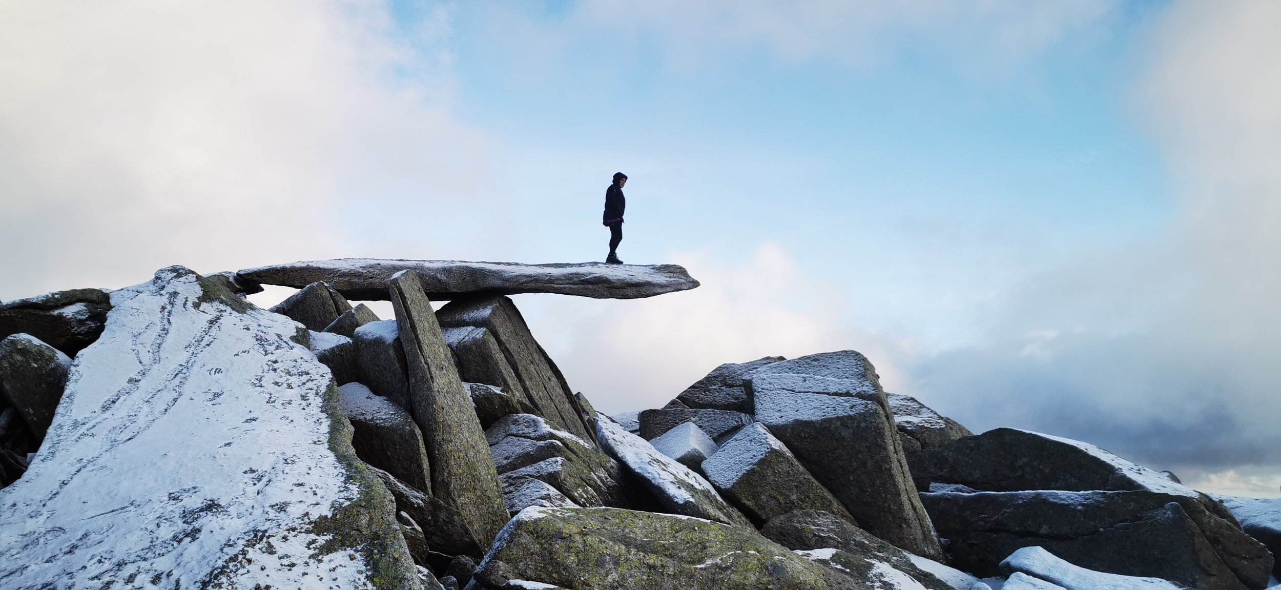
Y Gwyliwr / the cantilever stone
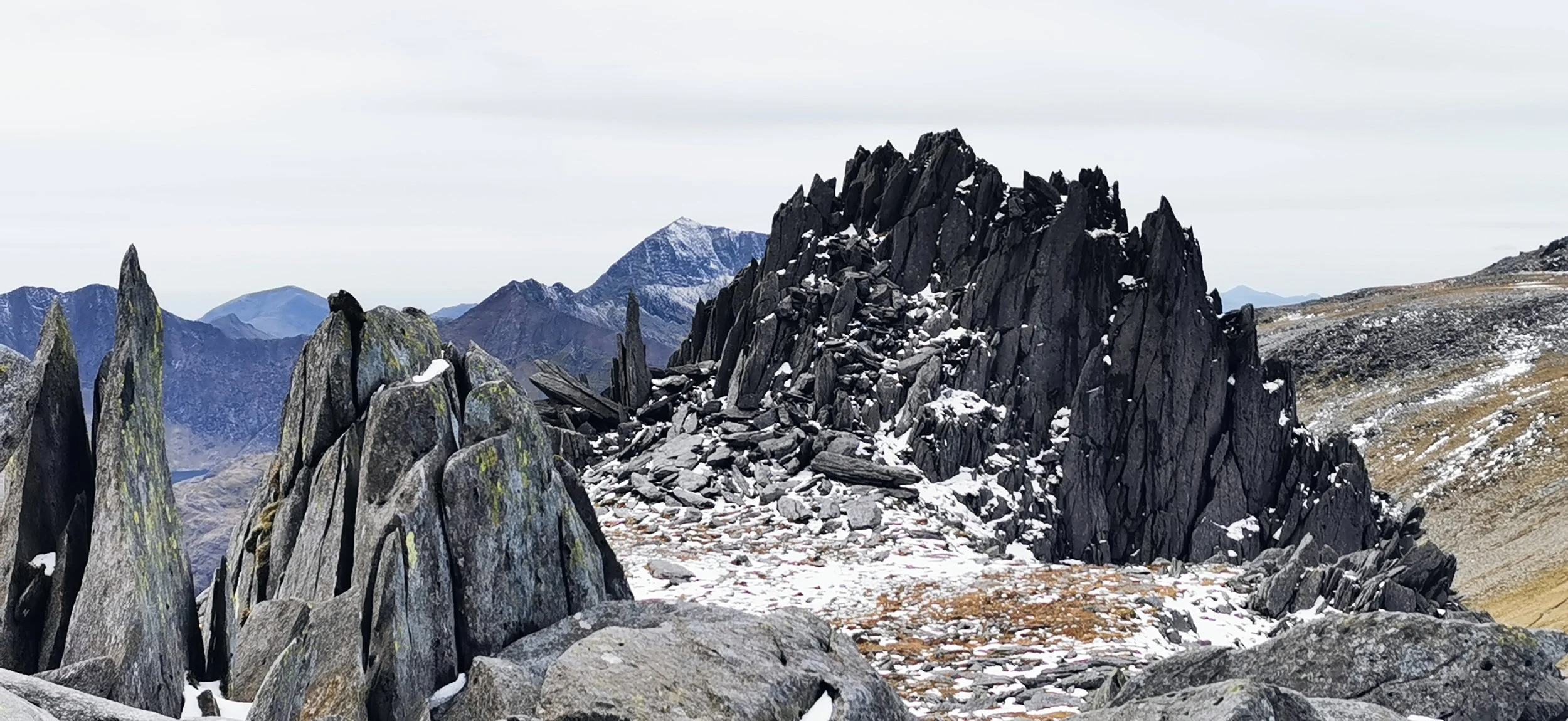
Castell y Gwynt

Bypassing Castell y Gwynt to the south
Keep heading west - south west, with the cliffs above Cwm Cneifion to the north, and the steep ground above Waun Gron to the south. There are various outcrops of rocks here which can be disorienting in low cloud. The summit isn’t that discernable from this approach, so a bearing from a known point above the cliffs of Cwm Cneifion could be useful. In poor weather a bearing will certainly be valuable for the descent onto the broad grassy ridge leading south west from the summit.

Cliffs above Cwm Cneifion with Y Garn in the distance.
In good weather, lap up the views of the Snowdon Horseshoe, with Crib Goch, Garnedd Ugain, Yr Wyddfa and Y Lliwedd all out in front of you as you descend easily on the grass for almost a kilometre. From here you want to keep Llyn Cwmffynon to your left (east) and pick your way down through the crags, with paths in places, towards it.

Heading down the broad grassy ridge south of Glyder Fawr

Descending to Llyn Cwmffynnon
From the lake you have two options; cross the stile over a fence and skirt over Moel Berfedd, through boggy and tussocky ground to return to the stile next to the Pen y Gwyryd; or, head south of the lake and descend near the hostel at Pen y Pass, cross the road, and return using the path that skirts underneath the road finishing just south of the Pen Y Gwyryd.

Llyn Cwmffynnon from Moel Berfedd
Please note this route is for information and inspiration only and we can’t be held responsible for any inaccuracies or problems arising. As this is rough mountain terrain you should take a paper map and compass and be able to use them. Please be Adventure Smart.