The Snowdonia Way

View from the Snowdonia Way
The Snowdonia Way…
A relatively new conception, the Snowdonia Way is a long distance walking route through Eryri from Machynlleth to Conwy, devised by Alex Kendall in 2017, as detailed in his guidebook published by Cicerone. There are two options for walking the Snowdonia Way; the main route of 97 miles and almost 5,500 metres of ascent, and the mountain route, 122 miles long and 12,200 metres of ascent. I have walked the main route twice, but only sections of the mountain route, so for the time being this write-up will cover the main route, which takes 6 to 7 days to complete if you do each stage as suggested (there is an option to split the final long stage).
The main route of the Snowdonia Way begins and ends each stage at locations where it is possible to restock water, food and find a bed for the evening. Some of the stages also have facilities part way through, but generally it is a good idea to be self-sufficient for the whole day. The route is well connected with public transport in parts, and more information on this can be found in the guidebook. I made use of local buses on several occasions when I needed to return to the beginning of a leg, or travel from the end point to begin a stage - helpful if you’re doing the walk in sections rather than in one go.
Although primarily a lowland route on paths, the main route of the Snowdonia Way is far from easy and there is mud, bogs, slate, boulders, stiles, rain, and wind to be navigated even in summer. It is not waymarked, so the guidebook is the principal source of navigation. I found the guidebook to be excellent, serving its purpose well, but it was also useful for me to have access to more detailed mapping, and I used OS maps online alongside the guidebook. This meant that if I needed to avoid a particularly boggy section, navigate around a field of frankly terrifying cows or make a detour to a pub or cafe for lunch, I could easily do so. Choosing footwear is tricky with such a wide variety of terrain; the lane walking sections can feel torturous in stiff soled boots, but you will also be glad of them in the mud, bogs and steep sections. I chose to wear lightweight Hoka’s Trail Code goretex which are super lightweight and bouncy for the lanes, but with just enough ankle support and grip to support me in bogs and over slippery rocks while carrying a heavy pack. Trekking poles are immensely handy and I’d always recommend taking some. At the time of writing the trail is blissfully quiet, and is unlikely to become the next West Highland Way any time soon, but it deserves much more attention as a great long distance walking route to discover Eryri National Park.
Stage 1
Machynlleth to Dolgellau
15.5 miles, 750 metres of ascent
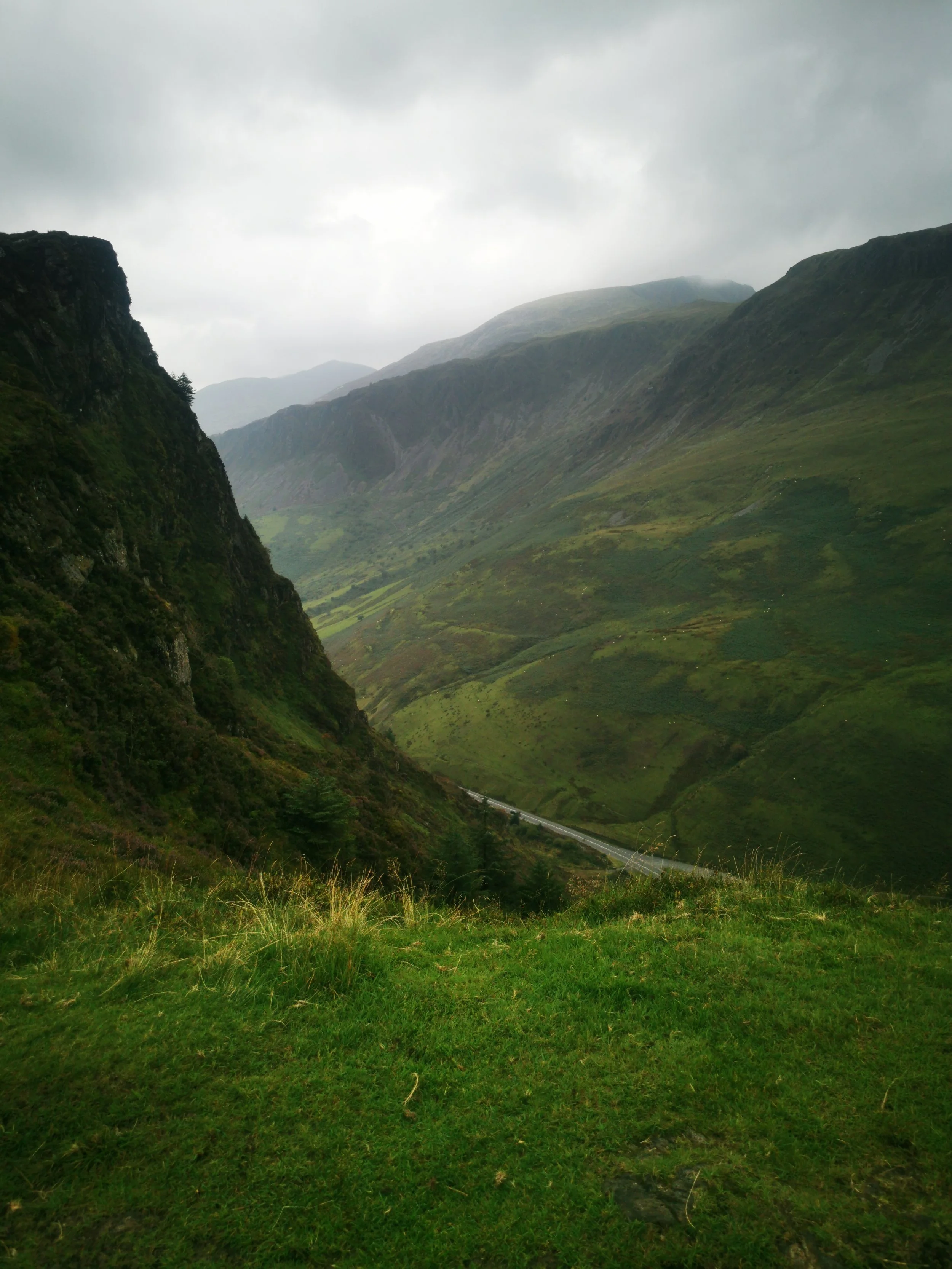
Stage one of the Snowdonia Way begins at the iconic town clock, and then passes the train station, so if you’re not a purist and are arriving by train or bus then you can begin there. After a short section on pavement on the main road the route soon joins a tranquil riverside path along the Dyfi river. There is then a long section of road walking along a very quiet lane, past the Centre for Alternative Technology, and towards Corris, where a detour is possible into the village for drinks etc. The route then runs alongside the incredibly pretty Afon Dulas, through quiet fields on grassy pathways, ending in the village of Aberllefenni where there is a lovely picnic spot with benches perfect for a lunch stop. Turning out of the village a steady climb takes you into the old quarry workings and spoil tips with incredible views of the huge mine on the far side of the valley. This valley, the Llefenni, is extremely quiet and feels a world away from everything, and is for me, the highlight of stage 1. A pathway winds through the pasture, woodland and hillside of the valley, before climbing very steeply on an unfrequented road to the day’s high point. Here is suggest taking a very short diversion up the grassy hillside to the left before the track heads downhill, for a wonderful view over Bwlch Llyn Bach and the lower cliffs of Cader Idris. With lucky timing you may also see a fighter jet at eye-level here; this is the ‘Mach loop’ a regular training ground for military aircraft. The route crosses a main road and then follows a cycle route along quiet lanes and tracks until entering fields and woodland again for the final descent into Dolgellau. It is possible to stay in Dolgellau itself, but on one occasion we chose to have dinner in the town then continue on the first mile of stage 2 to stay in a camping pod which was dog friendly. Be warned, if you decide to do this that final mile of the day is going to feel HARD as it is on a ridiculously steep hill!
Where to stay:
In Dolgellau centre, run by keen walkers - Plas Isa guesthouse
For a dog friendly option with small self-catering kitchen and honesty box supplies - Motocamp Wales
Where to eat:
Amazing pizzas, roaring fire, dog lovers, longer opening times for if you arrive in late - The Stag Inn
For the best coffee, cakes and delicious walker’s breakfasts - TH Roberts


Stage 2
Dolgellau to Trawsfynydd
14 miles, 790 metres of ascent
If you choose to stay at the campsite, you’ll feel very smug this morning and may even choose to have a relaxed start, as you’re already a mile and one huge hill on from the start of stage 2. If you’ve stayed in Dolgellau then be prepared for a brisk warm up as you climb up the hill, pass the campsite then descend to the Mawddach river, crossing it and the main road (bus connection option). You’ll then begin climbing high up onto the hillside through woodland and on a rough muddy and grassy path that snakes high above the river valley. The first time I walked this section there were no views as a thick mist hung in the valley, but the second time I was able to fully appreciate the beautiful views over the lush countryside below. The route enters ancient woodland and pasture with farms and cottages straight out of a fairy tale. Route finding can be a bit tricky on this section because some paths have been diverted and some changes in direction do not have the rights of way well signposted on the ground, so have the guidebook and map close to hand. The route crosses the main road that runs through the valley (bus connection option) and enters the Coed y Brenin woodland, crossing a bridge where the Mawddach rushes underneath, to a picnic area with toilets. After this comes several miles of gravelly forestry tracks, walking always to the sound of the river and goldcrests singing in the conifer trees overhead. There are some spectacularly large fir trees on this section, and a narrow footbridge crosses a pretty section of deep gorge; an area where gold mining took place for many years. Continuing on forest tracks, the route climbs up higher. There is an option to divert here following a lower track to Coed y Brenin visitor centre. As of March 25 the cafe and small shop is unfortunately due to close, which is a massive shame, as it is a welcome pitstop for lunch or shelter on a very wet day (speaking from experience!). Toilets will remain here and there are talks to try to get a new private company to take over the cafe so it still may be worth the diversion. To return to the route you can take a unfrequented, narrow path uphill through thick woodland to reach the track at the top again. As the forestry track eventually relents to more open hillside, if you’re lucky with the weather, the Rhinogydd mountains will come into view to your west. You’re now walking along an old Roman road and it feels wonderfully remote and ancient up at the top. The track winds through moorland before reaching a lane. The route diverts you from the lane onto rights of way through farmland, but I found this to be awkward, on one occasion having to wade through shin-deep cow slurry to cross a farmyard only to be faced with a field of over-friendly cows and having to backtrack. The second time I opted to stay on the lane as it is very quiet and pleasant enough, and brings you out at the same point as the farmland route. Trawsfynydd is a friendly village, unaffected by overtourism and here you can find a shop, pub and bus connection. Be sure to visit the statue of Hedd Wyn and learn about this most famous of Welsh poets.
Where to stay
Basic but comfortable huge rooms in the creaky upstairs of the only pub in the village, with genuinely friendly and welcoming staff, a huge log fire and great pub meals - Cross Foxes Bunkhouse
A little further along, a mile or so into Stage 3, with two large camping fields and cabins on the lake’s edge, fills up so book in advance - Cae Adda Camping
Two convenience stores in Trawsfynydd village, or for cooked meals the Cross Foxes has great pub meals with lots of locally sourced ingredients.


Stage 3
Trawsfynydd to Beddgelert
18.5 miles, 930 metres ascent
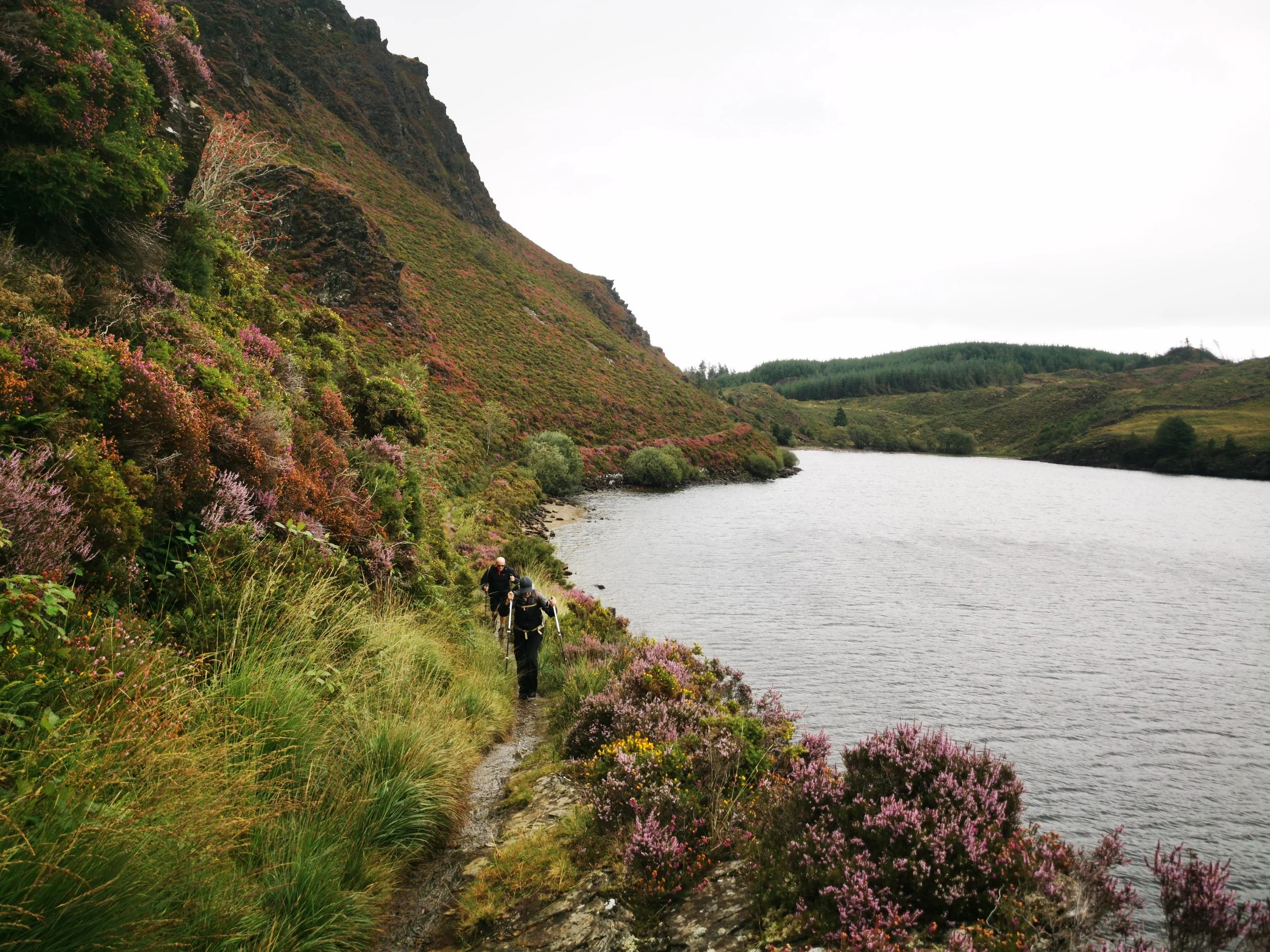
Today is a big day, crossing from south Eryri to the north of the national park, passing lakes, through ancient woodland, crossing an estuary and heather clad foothills. If you’ve stayed in Traws, as the local affectionately call it, then you’ll have to return to the main road then take the road leading along the south end of Llyn Trawsfynydd, as unfortunately the footbridge has been closed for several years with no signs of the repair works needed to reopen it. If you’ve stayed at the campsite then you’re already a couple of miles in and you route will begin on the excellent gravel cycle path which circumnavigates the lake. The views here are beautiful and on one occasion I spotted an osprey flying past, so do keep your eyes peeled for wildlife. Past the enormous dam at the western end of the lake, the route enters ancient celtic rainforest. A magical trail through twisty ancient oaks, rumoured to have once come to life to help an ancient Welsh prince in battle, stirs the imagination. There has been much logging in the plantation forestry which surrounds this, I believe since the book was written, and the way is neither easy nor pleasant to follow, in fact I spent fourty five minutes thigh-deep in bog on my first time on this route. The second time I took a diversion next to Llenyrch Farm towards Llyn Llenyrch through admittedly, quite cow-y farmland, but on a track which was very pleasant to walk along with excellent views up towards Moel Ysgyfarnogod. I imagine the later version of the guide book will have an updated route. The walk around the length of Llyn Tecwyn Isaf below the crags of Moel Tecwyn is beautiful, despite the pylons which are ever-present on this part of the route. The descent to Llandecwyn (train connection) is equally lovely. Some pavement walking next to a busy road ensues to cross the magnificent Dwyryd estuary - look out for the colourful buildings of Portmeirion on the other side to your left. Penrhyndeudraeth (bus connection) is an excellent place to stop for lunch, with real locals’ pubs, shops and cafes - take your pick! The guidebook really does a great job in describing it’s fairly tricky way out of town, and if you’re lucky you’ll get to see the steam train puffing along its tracks - you could even hop on it if you have had enough walking for the day as it’ll take you right into Beddgelert, or you could get off at Nantmor and walk the final couple of miles along the Aberglaslyn Pass which is not to be missed! If you do opt to take the train, what you’ll miss is a walk through a pretty section of woodland and farmland, running alongside the train for some way, and several kilometres of lane walking with wonderful views out to sea in the distance. The tiny village of Croesor has toilet facilities in the car park but unfortunately the community cafe is no longer open. The route joins the Llwybr Llechi Eryri / Snowdonia Slate Trail, on a track through open hillside with stunning views of the surrounding mountains. Descending into Nantmor, the final couple of miles follows the old fishermans path alongside the Glaslyn river, an exhilarating and picturesque pathway which some may find challenging - it goes perilously close to the edge at some parts and there are several large boulders to negotiate. A word of warning - this path can and does get flooded after heavy rain. The only real alternative is the busy lane on the opposite bank of the river, with no pavement. Arriving into Beddgelert you’ll find a plethora of shops, cafes, pubs and places to stay.
Where to Stay
A gorgeous b&b right in the centre, book well in advance - Plas Tan y Graig
You could easily imagine yourself an 18th century traveller staying at the Tanronnen Inn, in the centre
A luxury option in the village - Ty Afon
Just out of the centre of the village, this huge campsite is right on the Snowdonia Way and has good facilities including laundry - Cae Du Campsite
Where to Eat
Delicious meals, with candlelit indoor, and riverside outdoor tables - Bistro Hebog
Wood fired pizza and locally made ice cream, enough said! Glaslyn
The best coffee & cakes in the village - The Real Coffee Stop
Supplies and Info
There is also a very well stocked village shop for food supplies, a great tourist information centre and Crib Goch outdoor equipment shop in the centre of the village.


Stage 4
Beddgelert to Dolwyddelan
13 miles, 800 metres ascent
This stage offers one of my favourite views of the whole trail, so hope for a good weather day. Leaving Beddgelert the first part of the day, following the Glaslyn river to Llyn Dinas, past the Sygun Copper Mines is flat and enjoyable. Continuing around Llyn Dinas on a very easy lakeside path, reaching the road there are toilets, water refill and the wonderful Caffi Gwynant. The route then enters fields of a National Trust farm, then climbs up on boggy terrain to the wooded rocky outcrop above Llyn Gwynant. This is trickier ground and can be very boggy, but you’ll soon arrive at a large campsite, where if you’re lucky the campsite shop / pizza van may be open. Shortly afterwards the day’s long uphill climb begins, very steeply, on a well marked pathway. Near the top of the saddle at Bwlch y Rhediad, pause to look back and take in the breathtaking view over Gwynant and the Hebog range in the far distance, as well as the chance to view the summit of Yr Wyddfa (Snowdon) on a clear day. The landscape then takes a dramatic turn, from wooded, verdant valley, to broad, open, vast upland with waterlogged and wind bleached grassland. Careful route finding is again necessary here, until you cross a stream and join a well-worn track which takes you all the way down through farmland at Coed Mawr farm. Here you’ll want to toss up the options of taking the official guidebook route through fields, which does give you a good view of the rail tunnel, or whether to stick to the high road, following a lane and cutting off a bit of descent and ascent. It is a trade-off between grassy, muddy trails, and tarmac, but both options converge onto a track which has a great view of Dolwyddelan Castle which it passes closely, shortly before arriving into the village of Dolwyddelan. This is the end of the stage, though if you have a few more miles in you, you could consider adding on the walk over to Capel Curig, digging into the beginning of the next stage, for a wider range of facilities.
Where to Stay and Eat
In Dolwyddelan, historic, cosy, family run hotel with meals - Elen’s Castle Hotel
Newly refurbished food in a traditional local’s pub, with authentic home cooked Thai food - Y Gwydr Hotel
In Capel Curig, there are several options including The Rocks at Plas Curig Hostel, The Bryn, and Plas y Brenin, as well as a campsite at Bryn Tyrch Farm.
Supplies
There is a well-stocked Spar in Dolwyddelan, and two outdoor equipment shops in Capel Curig.


Stage 5
Dolwyddelan to Bethesda
15.5 miles, 660 metres ascent
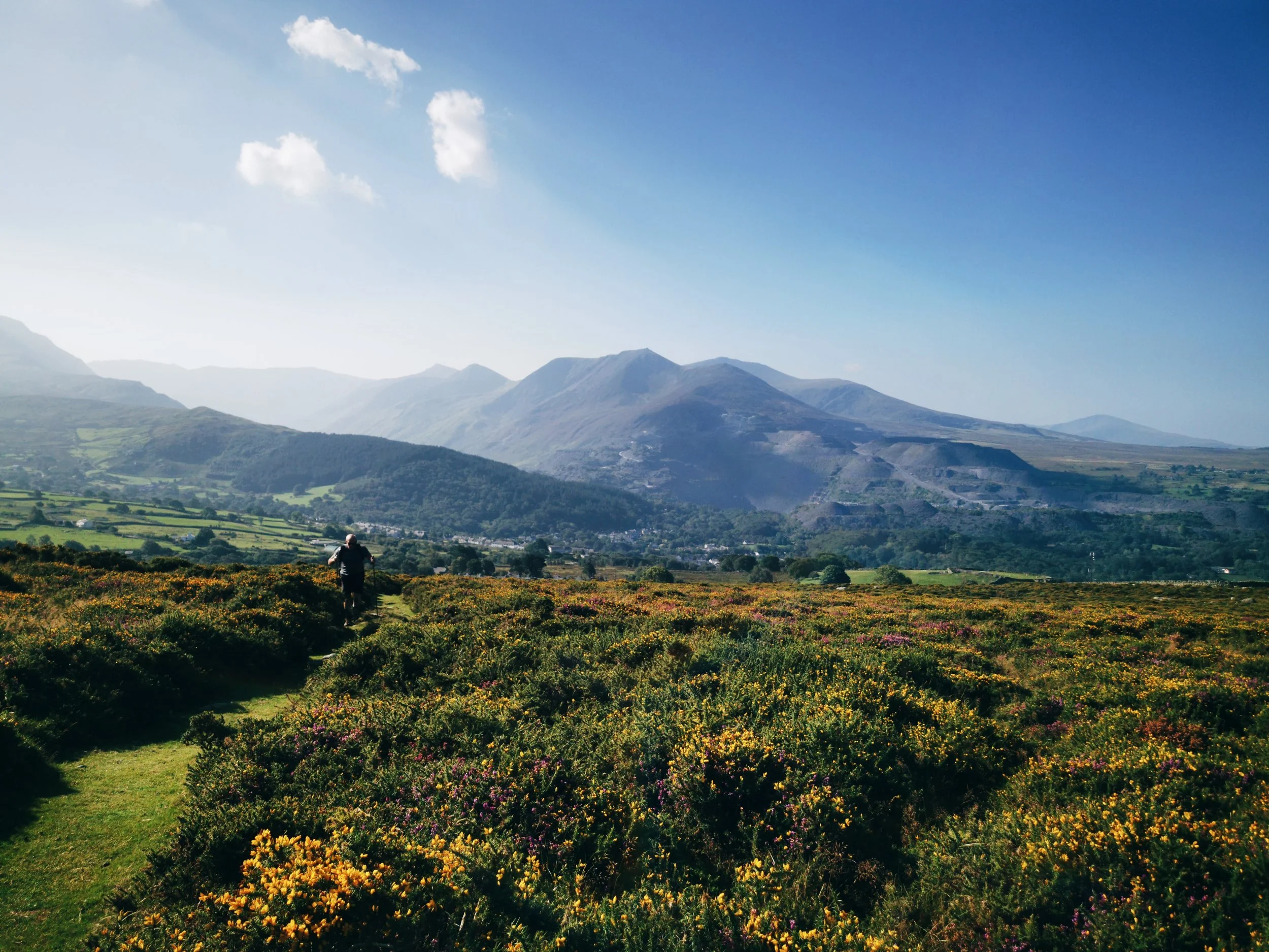
From Dolwyddelan the route climbs up through plantation forestry below the bulk of Moel Siabod before cresting and dropping steeply to Capel Curig (bus connection), with exceptional views over the Glyderau and Carneddau range. From Capel Curig the route follows the old Roman road through the Ogwen Valley; one of Eryri’s finest valleys between two of the highest mountain ranges. The views as you walk through this valley are simply breathtaking and until you reach Llyn Ogwen, the going is good. The traverse of Llyn Ogwen is rough going but it is worth it for the views of Tryfan and Y Garn reflected in the lake. Ogwen Cottage has a visitor centre with toilets and kiosk for snacks and drinks and a bus connection. There is also a hostel here. Today is one of the most scenic days of the whole walk so take time to enjoy it. Once past Ogwen Cottage the route is entirely downhill and good going on tarmac and gravel almost all the way to Bethesda, so the miles soon get eaten up. The final few miles are interesting as they skirt the slate spoil tips of the enormous Penrhyn quarry and the Zip World attraction. A small area of woodland ensures a pleasant entry into Bethesda, and the route conveniently deposits you next to a great local pub for a warm drink by the fire or cold cider on the outside deck, depending on the day you’ve had!
Where to Stay
Camping pods, some with hot tubs! Right next to the river, before you reach the town - Ogwen Bank
A fantastic pub, in the centre of Bethesda, plan to have rooms available soon - Tafarn Tryfan
For camping, it may be worth taking the park and ride bus back up to the top of the Ogwen Cottage where there are several campsites including - Gwern Gof Isaf and Gwern Gof Uchaf
The closest hostel is in the Nant Francon valley and can be accessed by bus from Bethesda or by diverting before you get to the slate quarry - Ogwen Valley Bunkhouse
Where to Eat and Supplies
There are several cafes in Bethesda but opening hours aren’t particularly helpful for walkers as they open late and close early. Tafarn Tryfan is the best bet for pub food. There is a Tesco Express on the main road for supplies. Otherwise there are several takeaways including fish and chips.


Stage 6
Bethesda to Conwy
21 miles, 1480 metres ascent
This is a long and challenging stage, but it can be easily broken into two easier days by staying at Llanfairfechan. There is a steep climb out of Bethesda, pause to look back at the mountains behind and you’ll really get a sense of scale of the slate quarrying. Once this is out of the way the going is very pleasant for several miles, traversing the grassy foothills of the Carneddau range. On both occasions I saw Carneddau ponies on this stretch, and on one I watched a hen harrier swooping along the moorland. There are wonderful views across the Menai Strait to Ynys Mon, Anglesey. Changing direction, the Rhaeadr Fawr valley opens up with the waterfall cascading dramatically down the mountainside at the head. The route circumnavigates the valley, crossing a bridge directly underneath the falls, one of the highlights of this stage, though startlingly busy in comparison to the beginning of the walk. Soon the crowds are left behind as you climb again, and the views open up again out to the coast. Another steep descent takes you to Llanfairfechan, and it is here that you can choose to overnight if you want to split the stage. The town itself is further downhill from the route, but there is an option for an overnight stay directly on the route, up on the opposite hillside, which you pass as you begin the final long climb of the Snowdonia Way. The final stretch of the route to Conwy passes over heather clad moorland with some impressive ancient stone circles to view on route. Dropping down to the Sychnant Pass the descent into Conwy is gentle and there is a sense of occasion as you catch a glimpse of the huge castle ahead. Reaching the north coast finally, the scale of the journey you’ve undertaken, across the entire length of Eryri National Park, and one third of the length of Wales, begins to sink in. Once in Conwy you’ll have all the facilities that you need, plus train and bus connections. There isn’t a direct connection back to Machynlleth from here if you need it, but you can piece together a return journey using buses or trains.
Where to Stay
Just a little way off the route, inland from Llanfairfechan, with several glamping pods - Three Streams Glamping
On the route uphill from Llanfairfechan, ask in advance for an evening meal, a country house style guest house - Plas Heulog
Campsite close to the town centre of Llanfairfechan - Platt’s Farm
Great b&b in the centre of Conwy, close to the train station and castle - Number 18 Conwy
Hostel with bell tents, dorms and private rooms - YHA Conwy
Where to Eat
In Conwy, to treat yourself to a gastro pub meal after the long walk, also has rooms - The Erskine Arms
My favourite cosy spot in the walled town at Conwy for lunch or coffee and cake - L’s Coffee and Book Shop
Don’t miss a stroll along the quayside for fish and chips or ice cream.


Are you thinking of walking the Snowdonia Way? Or have you walked it? I’d love to hear your experiences and I will do my best to answer any questions you may have, just leave a comment below.
This guide is for inspiration only and I cannot be held responsible for any issues arising from the use of this article. Please Be Adventure Smart and ensure you have the right skills, experience and equipment before undertaking any walk in remote terrain.
This article was inspired by my experiences walking the Snowdonia Way, a route which was designed by Alex Kendall and which is described in the official guidebook. I hope that this write up inspires you to get a copy of the book and walk the route for yourself!